
File:"A Rugged Scot" - geograph.org.uk - 1613360.jpg
From Wikimedia Commons, the free media repository
No higher resolution available.
"A_Rugged_Scot"_-_geograph.org.uk_-_1613360.jpg (450 × 600 pixels, file size: 40 KB, MIME type: image/jpeg)
File information
Structured data
Captions
Captions
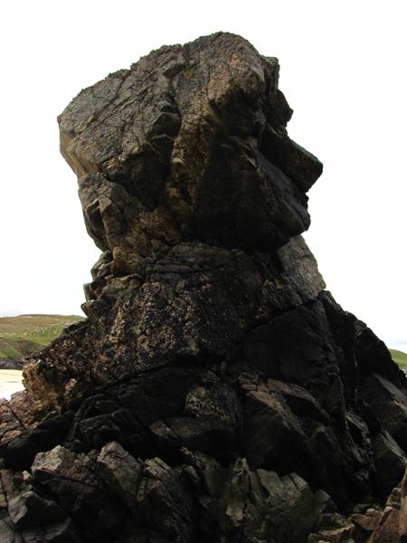
"A Rugged Scot"
Summary
[edit]
| Description"A Rugged Scot" - geograph.org.uk - 1613360.jpg |
English: "A Rugged Scot" Erosion has created this stack shaped clearly as a head. The rock sits on the north side of Mangersta Beach. |
| Date | |
| Source | From geograph.org.uk |
| Author | John Tustin |
| Attribution (required by the license) InfoField | John Tustin / "A Rugged Scot" / |
InfoField | John Tustin / "A Rugged Scot" |
| Camera location | 58° 09′ 54″ N, 7° 05′ 27″ W | View this and other nearby images on: OpenStreetMap |
|---|
_heading:247.00&language=en)
| Object location | 58° 09′ 54″ N, 7° 05′ 27″ W | View this and other nearby images on: OpenStreetMap |
|---|
_heading:247.00&language=en)
Licensing
[edit]

|
This image was taken from the Geograph project collection. See this photograph's page on the Geograph website for the photographer's contact details. The copyright on this image is owned by John Tustin and is licensed for reuse under the Creative Commons Attribution-ShareAlike 2.0 license.
|
This file is licensed under the Creative Commons Attribution-Share Alike 2.0 Generic license.
Attribution: John Tustin
- You are free:
- to share – to copy, distribute and transmit the work
- to remix – to adapt the work
- Under the following conditions:
- attribution – You must give appropriate credit, provide a link to the license, and indicate if changes were made. You may do so in any reasonable manner, but not in any way that suggests the licensor endorses you or your use.
- share alike – If you remix, transform, or build upon the material, you must distribute your contributions under the same or compatible license as the original.
File history
Click on a date/time to view the file as it appeared at that time.
| Date/Time | Thumbnail | Dimensions | User | Comment | |
|---|---|---|---|---|---|
| current | 08:51, 4 March 2011 | | 450 × 600 (40 KB) | GeographBot (talk | contribs) | == {{int:filedesc}} == {{Information |description={{en|1="A Rugged Scot" Erosion has created this stack shaped clearly as a head. The rock sits on the north side of Mangersta Beach.}} |date=2009-09-04 |source=From [http://www.geograph.org.uk/photo/1613360 |
You cannot overwrite this file.
File usage on Commons
There are no pages that use this file.
Metadata
This file contains additional information such as Exif metadata which may have been added by the digital camera, scanner, or software program used to create or digitize it. If the file has been modified from its original state, some details such as the timestamp may not fully reflect those of the original file. The timestamp is only as accurate as the clock in the camera, and it may be completely wrong.
| Camera manufacturer | Canon |
|---|---|
| Camera model | Canon PowerShot SX1 IS |
| Exposure time | 1/250 sec (0.004) |
| F-number | f/4 |
| ISO speed rating | 80 |
| Date and time of data generation | 10:53, 4 September 2009 |
| Lens focal length | 5 mm |
| Horizontal resolution | 180 dpi |
| Vertical resolution | 180 dpi |
| File change date and time | 10:53, 4 September 2009 |
| Y and C positioning | Co-sited |
| Exif version | 2.21 |
| Date and time of digitizing | 10:53, 4 September 2009 |
| Meaning of each component |
|
| Image compression mode | 5 |
| APEX shutter speed | 7.96875 |
| APEX aperture | 4 |
| APEX exposure bias | 0 |
| Maximum land aperture | 2.96875 APEX (f/2.8) |
| Metering mode | Center weighted average |
| Flash | Flash did not fire, compulsory flash suppression |
| Supported Flashpix version | 1 |
| Color space | sRGB |
| Focal plane X resolution | 15,116.022099448 |
| Focal plane Y resolution | 15,136.929460581 |
| Focal plane resolution unit | inches |
| Sensing method | One-chip color area sensor |
| File source | Digital still camera |
Structured data
depicts"}},"text//plain":{"en":{"":"depicts"}}},"{/"value/":{/"entity-type/":/"item/",/"numeric-id/":8063,/"id/":/"Q8063/"},/"type/":/"wikibase-entityid/"}":{"text//html":{"en":{"P180":"rock"}},"text//plain":{"en":{"P180":"rock"}}},"{/"value/":{/"entity-type/":/"item/",/"numeric-id/":468533,/"id/":/"Q468533/"},/"type/":/"wikibase-entityid/"}":{"text//html":{"en":{"P180":"Uig"}},"text//plain":{"en":{"P180":"Uig"}}}}" class="wbmi-entityview-statementsGroup wbmi-entityview-statementsGroup-P180 oo-ui-layout oo-ui-panelLayout oo-ui-panelLayout-framed">
creator"}},"text//plain":{"en":{"":"creator"}}},"{/"value/":{/"entity-type/":/"property/",/"numeric-id/":3831,/"id/":/"P3831/"},/"type/":/"wikibase-entityid/"}":{"text//html":{"en":{"":"object of statement has role<\/a>"}},"text\/plain":{"en":{"":"object of statement has role"}}},"{\"value\":{\"entity-type\":\"item\",\"numeric-id\":33231,\"id\":\"Q33231\"},\"type\":\"wikibase-entityid\"}":{"text\/html":{"en":{"P3831":"<a target=\"_blank\" title=\"d:Special:EntityPage\/Q33231\" href=https://commons.wikimedia.org/"https:////www.wikidata.org//wiki//Special:EntityPage//Q33231/">photographer"}},"text//plain":{"en":{"P3831":"photographer"}}},"{/"value/":{/"entity-type/":/"property/",/"numeric-id/":2093,/"id/":/"P2093/"},/"type/":/"wikibase-entityid/"}":{"text//html":{"en":{"":"author name string<\/a>"}},"text\/plain":{"en":{"":"author name string"}}},"{\"value\":\"John Tustin\",\"type\":\"string\"}":{"text\/html":{"en":{"P2093":"John Tustin"}},"text\/plain":{"en":{"P2093":"John Tustin"}}},"{\"value\":{\"entity-type\":\"property\",\"numeric-id\":2699,\"id\":\"P2699\"},\"type\":\"wikibase-entityid\"}":{"text\/html":{"en":{"":"<a target=\"_blank\" title=\"d:Special:EntityPage\/P2699\" href=https://commons.wikimedia.org/"https:////www.wikidata.org//wiki//Special:EntityPage//P2699/">URL"}},"text//plain":{"en":{"":"URL"}}},"{/"value/":/"https:////////www.geograph.org.uk////profile////33838/",/"type/":/"string/"}":{"text//html":{"en":{"P2699":"https:////www.geograph.org.uk//profile//33838"}},"text//plain":{"en":{"P2699":"https:////www.geograph.org.uk//profile//33838"}}}}" class="wbmi-entityview-statementsGroup wbmi-entityview-statementsGroup-P170 oo-ui-layout oo-ui-panelLayout oo-ui-panelLayout-framed">
copyright status<\/a>"}},"text\/plain":{"en":{"":"copyright status"}}},"{\"value\":{\"entity-type\":\"item\",\"numeric-id\":50423863,\"id\":\"Q50423863\"},\"type\":\"wikibase-entityid\"}":{"text\/html":{"en":{"P6216":"<a target=\"_blank\" title=\"d:Special:EntityPage\/Q50423863\" href=https://commons.wikimedia.org/"https:////www.wikidata.org//wiki//Special:EntityPage//Q50423863/">copyrighted"}},"text//plain":{"en":{"P6216":"copyrighted"}}}}" class="wbmi-entityview-statementsGroup wbmi-entityview-statementsGroup-P6216 oo-ui-layout oo-ui-panelLayout oo-ui-panelLayout-framed">
copyright license<\/a>"}},"text\/plain":{"en":{"":"copyright license"}}},"{\"value\":{\"entity-type\":\"item\",\"numeric-id\":19068220,\"id\":\"Q19068220\"},\"type\":\"wikibase-entityid\"}":{"text\/html":{"en":{"P275":"<a target=\"_blank\" title=\"d:Special:EntityPage\/Q19068220\" href=https://commons.wikimedia.org/"https:////www.wikidata.org//wiki//Special:EntityPage//Q19068220/">Creative Commons Attribution-ShareAlike 2.0 Generic<\/a>"}},"text\/plain":{"en":{"P275":"Creative Commons Attribution-ShareAlike 2.0 Generic"}}},"{\"value\":{\"entity-type\":\"property\",\"numeric-id\":1476,\"id\":\"P1476\"},\"type\":\"wikibase-entityid\"}":{"text\/html":{"en":{"":"<a target=\"_blank\" title=\"d:Special:EntityPage\/P1476\" href=https://commons.wikimedia.org/"https:////www.wikidata.org//wiki//Special:EntityPage//P1476/">title"}},"text//plain":{"en":{"":"title"}}},"{/"value/":{/"text/":/"///"A Rugged Scot\\\"\",\"language\":\"en\"},\"type\":\"monolingualtext\"}":{"text\/html":{"en":{"P1476":"<span lang=\"en\" class=\"wb-monolingualtext-value\">\"A Rugged Scot\"<\/span> <span class=\"wb-monolingualtext-language-name\" dir=\"auto\">(English)<\/span>"}},"text\/plain":{"en":{"P1476":"\"A Rugged Scot\""}}},"{\"value\":{\"entity-type\":\"property\",\"numeric-id\":2093,\"id\":\"P2093\"},\"type\":\"wikibase-entityid\"}":{"text\/html":{"en":{"":"<a target=\"_blank\" title=\"d:Special:EntityPage\/P2093\" href=https://commons.wikimedia.org/"https:////www.wikidata.org//wiki//Special:EntityPage//P2093/">author name string<\/a>"}},"text\/plain":{"en":{"":"author name string"}}},"{\"value\":\"John Tustin\",\"type\":\"string\"}":{"text\/html":{"en":{"P2093":"John Tustin"}},"text\/plain":{"en":{"P2093":"John Tustin"}}}}" class="wbmi-entityview-statementsGroup wbmi-entityview-statementsGroup-P275 oo-ui-layout oo-ui-panelLayout oo-ui-panelLayout-framed">
inception"}},"text//plain":{"en":{"":"inception"}}},"{/"value/":{/"time/":/"+2009-09-04T00:00:00Z/",/"timezone/":0,/"before/":0,/"after/":0,/"precision/":11,/"calendarmodel/":/"http:////////www.wikidata.org////entity////Q1985727/"},/"type/":/"time/"}":{"text//html":{"en":{"P571":"4 September 2009"}},"text\/plain":{"en":{"P571":"4 September 2009"}}}}" class="wbmi-entityview-statementsGroup wbmi-entityview-statementsGroup-P571 oo-ui-layout oo-ui-panelLayout oo-ui-panelLayout-framed">
4 September 2009
coordinates of the point of view<\/a>"}},"text\/plain":{"en":{"":"coordinates of the point of view"}}},"{\"value\":{\"latitude\":58.16513,\"longitude\":-7.0909,\"altitude\":null,\"precision\":1.0e-5,\"globe\":\"http:\\\/\\\/www.wikidata.org\\\/entity\\\/Q2\"},\"type\":\"globecoordinate\"}":{"text\/html":{"en":{"P1259":"58\u00b09'54.47"N, 7\u00b05'27.24"W"}},"text\/plain":{"en":{"P1259":"58\u00b09'54.47\"N, 7\u00b05'27.24\"W"}}},"{\"value\":{\"entity-type\":\"property\",\"numeric-id\":7787,\"id\":\"P7787\"},\"type\":\"wikibase-entityid\"}":{"text\/html":{"en":{"":"<a target=\"_blank\" title=\"d:Special:EntityPage\/P7787\" href=https://commons.wikimedia.org/"https:////www.wikidata.org//wiki//Special:EntityPage//P7787/">heading"}},"text//plain":{"en":{"":"heading"}}},"{/"value/":{/"amount/":/"+247/",/"unit/":/"http:////////www.wikidata.org////entity////Q28390/"},/"type/":/"quantity/"}":{"text//html":{"en":{"P7787":"247 <span class=\"wb-unit\">degree<\/span>"}},"text\/plain":{"en":{"P7787":"247 degree"}}}}" class="wbmi-entityview-statementsGroup wbmi-entityview-statementsGroup-P1259 oo-ui-layout oo-ui-panelLayout oo-ui-panelLayout-framed">
58°9'54.47"N, 7°5'27.24"W
source of file<\/a>"}},"text\/plain":{"en":{"":"source of file"}}},"{\"value\":{\"entity-type\":\"item\",\"numeric-id\":74228490,\"id\":\"Q74228490\"},\"type\":\"wikibase-entityid\"}":{"text\/html":{"en":{"P7482":"<a target=\"_blank\" title=\"d:Special:EntityPage\/Q74228490\" href=https://commons.wikimedia.org/"https:////www.wikidata.org//wiki//Special:EntityPage//Q74228490/">file available on the internet<\/a>"}},"text\/plain":{"en":{"P7482":"file available on the internet"}}},"{\"value\":{\"entity-type\":\"property\",\"numeric-id\":137,\"id\":\"P137\"},\"type\":\"wikibase-entityid\"}":{"text\/html":{"en":{"":"<a target=\"_blank\" title=\"d:Special:EntityPage\/P137\" href=https://commons.wikimedia.org/"https:////www.wikidata.org//wiki//Special:EntityPage//P137/">operator"}},"text//plain":{"en":{"":"operator"}}},"{/"value/":{/"entity-type/":/"item/",/"numeric-id/":1503119,/"id/":/"Q1503119/"},/"type/":/"wikibase-entityid/"}":{"text//html":{"en":{"P137":"Geograph Britain and Ireland<\/a>"}},"text\/plain":{"en":{"P137":"Geograph Britain and Ireland"}}},"{\"value\":{\"entity-type\":\"property\",\"numeric-id\":7384,\"id\":\"P7384\"},\"type\":\"wikibase-entityid\"}":{"text\/html":{"en":{"":"<a target=\"_blank\" title=\"d:Special:EntityPage\/P7384\" href=https://commons.wikimedia.org/"https:////www.wikidata.org//wiki//Special:EntityPage//P7384/">geograph.org.uk image ID<\/a>"}},"text\/plain":{"en":{"":"geograph.org.uk image ID"}}},"{\"value\":\"1613360\",\"type\":\"string\"}":{"text\/html":{"en":{"P7384":"<a target=\"_blank\" class=\"wb-external-id external\" href=https://commons.wikimedia.org/"https:////www.geograph.org.uk//photo//1613360/" rel=\"nofollow\">1613360<\/a>"}},"text\/plain":{"en":{"P7384":"1613360"}}},"{\"value\":{\"entity-type\":\"property\",\"numeric-id\":973,\"id\":\"P973\"},\"type\":\"wikibase-entityid\"}":{"text\/html":{"en":{"":"<a target=\"_blank\" title=\"d:Special:EntityPage\/P973\" href=https://commons.wikimedia.org/"https:////www.wikidata.org//wiki//Special:EntityPage//P973/">described at URL<\/a>"}},"text\/plain":{"en":{"":"described at URL"}}},"{\"value\":\"https:\\\/\\\/www.geograph.org.uk\\\/photo\\\/1613360\",\"type\":\"string\"}":{"text\/html":{"en":{"P973":"<a target=\"_blank\" rel=\"nofollow\" class=\"external free\" href=https://commons.wikimedia.org/"https:////www.geograph.org.uk//photo//1613360/">https:////www.geograph.org.uk//photo//1613360"}},"text//plain":{"en":{"P973":"https:////www.geograph.org.uk//photo//1613360"}}}}" class="wbmi-entityview-statementsGroup wbmi-entityview-statementsGroup-P7482 oo-ui-layout oo-ui-panelLayout oo-ui-panelLayout-framed">
captured with<\/a>"}},"text\/plain":{"en":{"":"captured with"}}},"{\"value\":{\"entity-type\":\"item\",\"numeric-id\":20889036,\"id\":\"Q20889036\"},\"type\":\"wikibase-entityid\"}":{"text\/html":{"en":{"P4082":"<a target=\"_blank\" title=\"d:Special:EntityPage\/Q20889036\" href=https://commons.wikimedia.org/"https:////www.wikidata.org//wiki//Special:EntityPage//Q20889036/">Canon PowerShot SX1 IS<\/a>"}},"text\/plain":{"en":{"P4082":"Canon PowerShot SX1 IS"}}}}" class="wbmi-entityview-statementsGroup wbmi-entityview-statementsGroup-P4082 oo-ui-layout oo-ui-panelLayout oo-ui-panelLayout-framed">
coordinates of depicted place<\/a>"}},"text\/plain":{"en":{"":"coordinates of depicted place"}}},"{\"value\":{\"latitude\":58.16513,\"longitude\":-7.0909,\"altitude\":null,\"precision\":1.0e-5,\"globe\":\"http:\\\/\\\/www.wikidata.org\\\/entity\\\/Q2\"},\"type\":\"globecoordinate\"}":{"text\/html":{"en":{"P9149":"58\u00b09'54.47"N, 7\u00b05'27.24"W"}},"text\/plain":{"en":{"P9149":"58\u00b09'54.47\"N, 7\u00b05'27.24\"W"}}},"{\"value\":{\"entity-type\":\"property\",\"numeric-id\":7787,\"id\":\"P7787\"},\"type\":\"wikibase-entityid\"}":{"text\/html":{"en":{"":"<a target=\"_blank\" title=\"d:Special:EntityPage\/P7787\" href=https://commons.wikimedia.org/"https:////www.wikidata.org//wiki//Special:EntityPage//P7787/">heading"}},"text//plain":{"en":{"":"heading"}}},"{/"value/":{/"amount/":/"+247/",/"unit/":/"http:////////www.wikidata.org////entity////Q28390/"},/"type/":/"quantity/"}":{"text//html":{"en":{"P7787":"247 <span class=\"wb-unit\">degree<\/span>"}},"text\/plain":{"en":{"P7787":"247 degree"}}}}" class="wbmi-entityview-statementsGroup wbmi-entityview-statementsGroup-P9149 oo-ui-layout oo-ui-panelLayout oo-ui-panelLayout-framed">
58°9'54.47"N, 7°5'27.24"W
media type<\/a>"}},"text\/plain":{"en":{"":"media type"}}},"{\"value\":\"image\\\/jpeg\",\"type\":\"string\"}":{"text\/html":{"en":{"P1163":"image\/jpeg"}},"text\/plain":{"en":{"P1163":"image\/jpeg"}}}}" class="wbmi-entityview-statementsGroup wbmi-entityview-statementsGroup-P1163 oo-ui-layout oo-ui-panelLayout oo-ui-panelLayout-framed">
image/jpeg
checksum"}},"text//plain":{"en":{"":"checksum"}}},"{/"value/":/"4fb4a0d9c66f1df1111e2e378a63308823ac25f4/",/"type/":/"string/"}":{"text//html":{"en":{"P4092":"4fb4a0d9c66f1df1111e2e378a63308823ac25f4"}},"text//plain":{"en":{"P4092":"4fb4a0d9c66f1df1111e2e378a63308823ac25f4"}}},"{/"value/":{/"entity-type/":/"property/",/"numeric-id/":459,/"id/":/"P459/"},/"type/":/"wikibase-entityid/"}":{"text//html":{"en":{"":"determination method or standard<\/a>"}},"text\/plain":{"en":{"":"determination method or standard"}}},"{\"value\":{\"entity-type\":\"item\",\"numeric-id\":13414952,\"id\":\"Q13414952\"},\"type\":\"wikibase-entityid\"}":{"text\/html":{"en":{"P459":"<a target=\"_blank\" title=\"d:Special:EntityPage\/Q13414952\" href=https://commons.wikimedia.org/"https:////www.wikidata.org//wiki//Special:EntityPage//Q13414952/">SHA-1"}},"text//plain":{"en":{"P459":"SHA-1"}}}}" class="wbmi-entityview-statementsGroup wbmi-entityview-statementsGroup-P4092 oo-ui-layout oo-ui-panelLayout oo-ui-panelLayout-framed">
4fb4a0d9c66f1df1111e2e378a63308823ac25f4
data size<\/a>"}},"text\/plain":{"en":{"":"data size"}}},"{\"value\":{\"amount\":\"+41344\",\"unit\":\"http:\\\/\\\/www.wikidata.org\\\/entity\\\/Q8799\"},\"type\":\"quantity\"}":{"text\/html":{"en":{"P3575":"41,344 <span class=\"wb-unit\">byte<\/span>"}},"text\/plain":{"en":{"P3575":"41,344 byte"}}}}" class="wbmi-entityview-statementsGroup wbmi-entityview-statementsGroup-P3575 oo-ui-layout oo-ui-panelLayout oo-ui-panelLayout-framed">
41,344 byte
height"}},"text//plain":{"en":{"":"height"}}},"{/"value/":{/"amount/":/"+600/",/"unit/":/"http:////////www.wikidata.org////entity////Q355198/"},/"type/":/"quantity/"}":{"text//html":{"en":{"P2048":"600 <span class=\"wb-unit\">pixel<\/span>"}},"text\/plain":{"en":{"P2048":"600 pixel"}}}}" class="wbmi-entityview-statementsGroup wbmi-entityview-statementsGroup-P2048 oo-ui-layout oo-ui-panelLayout oo-ui-panelLayout-framed">
600 pixel
width"}},"text//plain":{"en":{"":"width"}}},"{/"value/":{/"amount/":/"+450/",/"unit/":/"http:////////www.wikidata.org////entity////Q355198/"},/"type/":/"quantity/"}":{"text//html":{"en":{"P2049":"450 <span class=\"wb-unit\">pixel<\/span>"}},"text\/plain":{"en":{"P2049":"450 pixel"}}}}" class="wbmi-entityview-statementsGroup wbmi-entityview-statementsGroup-P2049 oo-ui-layout oo-ui-panelLayout oo-ui-panelLayout-framed">
450 pixel
ISO speed<\/a>"}},"text\/plain":{"en":{"":"ISO speed"}}},"{\"value\":{\"amount\":\"+80\",\"unit\":\"1\"},\"type\":\"quantity\"}":{"text\/html":{"en":{"P6789":"80"}},"text\/plain":{"en":{"P6789":"80"}}}}" class="wbmi-entityview-statementsGroup wbmi-entityview-statementsGroup-P6789 oo-ui-layout oo-ui-panelLayout oo-ui-panelLayout-framed">
exposure time<\/a>"}},"text\/plain":{"en":{"":"exposure time"}}},"{\"value\":{\"amount\":\"+0.004\",\"unit\":\"http:\\\/\\\/www.wikidata.org\\\/entity\\\/Q11574\"},\"type\":\"quantity\"}":{"text\/html":{"en":{"P6757":"0.004 <span class=\"wb-unit\">second<\/span>"}},"text\/plain":{"en":{"P6757":"0.004 second"}}}}" class="wbmi-entityview-statementsGroup wbmi-entityview-statementsGroup-P6757 oo-ui-layout oo-ui-panelLayout oo-ui-panelLayout-framed">
0.004 second
f-number"}},"text//plain":{"en":{"":"f-number"}}},"{/"value/":{/"amount/":/"+4/",/"unit/":/"1/"},/"type/":/"quantity/"}":{"text//html":{"en":{"P6790":"4"}},"text//plain":{"en":{"P6790":"4"}}}}" class="wbmi-entityview-statementsGroup wbmi-entityview-statementsGroup-P6790 oo-ui-layout oo-ui-panelLayout oo-ui-panelLayout-framed">
focal length<\/a>"}},"text\/plain":{"en":{"":"focal length"}}},"{\"value\":{\"amount\":\"+5\",\"unit\":\"http:\\\/\\\/www.wikidata.org\\\/entity\\\/Q174789\"},\"type\":\"quantity\"}":{"text\/html":{"en":{"P2151":"5 <span class=\"wb-unit\">millimetre<\/span>"}},"text\/plain":{"en":{"P2151":"5 millimetre"}}}}" class="wbmi-entityview-statementsGroup wbmi-entityview-statementsGroup-P2151 oo-ui-layout oo-ui-panelLayout oo-ui-panelLayout-framed">
5 millimetre
geograph.org.uk image ID<\/a>"}},"text\/plain":{"en":{"":"geograph.org.uk image ID"}}},"{\"value\":\"1613360\",\"type\":\"string\"}":{"text\/html":{"en":{"P7384":"<a target=\"_blank\" class=\"wb-external-id external\" href=https://commons.wikimedia.org/"https:////www.geograph.org.uk//photo//1613360/" rel=\"nofollow\">1613360<\/a>"}},"text\/plain":{"en":{"P7384":"1613360"}}}}" class="wbmi-entityview-statementsGroup wbmi-entityview-statementsGroup-P7384 oo-ui-layout oo-ui-panelLayout oo-ui-panelLayout-framed">
instance of<\/a>"}},"text\/plain":{"en":{"":"instance of"}}},"{\"value\":{\"entity-type\":\"item\",\"numeric-id\":125191,\"id\":\"Q125191\"},\"type\":\"wikibase-entityid\"}":{"text\/html":{"en":{"P31":"<a target=\"_blank\" title=\"d:Special:EntityPage\/Q125191\" href=https://commons.wikimedia.org/"https:////www.wikidata.org//wiki//Special:EntityPage//Q125191/">photograph"}},"text//plain":{"en":{"P31":"photograph"}}}}" class="wbmi-entityview-statementsGroup wbmi-entityview-statementsGroup-P31 oo-ui-layout oo-ui-panelLayout oo-ui-panelLayout-framed">
location of creation<\/a>"}},"text\/plain":{"en":{"":"location of creation"}}},"{\"value\":{\"entity-type\":\"item\",\"numeric-id\":468533,\"id\":\"Q468533\"},\"type\":\"wikibase-entityid\"}":{"text\/html":{"en":{"P1071":"<a target=\"_blank\" title=\"d:Special:EntityPage\/Q468533\" href=https://commons.wikimedia.org/"https:////www.wikidata.org//wiki//Special:EntityPage//Q468533/">Uig"}},"text//plain":{"en":{"P1071":"Uig"}}}}" class="wbmi-entityview-statementsGroup wbmi-entityview-statementsGroup-P1071 oo-ui-layout oo-ui-panelLayout oo-ui-panelLayout-framed">